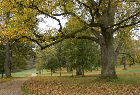
Nature trails
There are a total of 26 nature trails in Espoo, of which the city maintains nine. These city-maintained trails are located in various parts of Espoo, and give a great overall picture of the versatility and richness of local nature.
The trails are marked with paint markers and nature trail signs. The nature trails are not maintained in winter and do not have waste management. The nature and other hikers will thank you when you bring your waste from the nature to appropriate waste collection points.
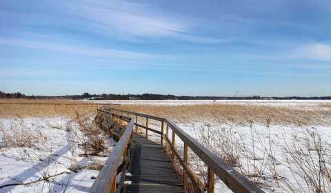
Along the nature trails, you will find information boards presenting the nature of the area and its special features. Information about other outdoor routes can be found on the Outdoor routes page. Several nature trails feature a birdwatching tower, offering an easy place to pause during your hike to admire the scenery, local birds, and surrounding nature.
Before your trip, read the Outdoor Etiquette(external link, opens in a new window) prepared by Metsähallitus. Open fires and camping are not allowed on nature trails. Allowed camping areas can be found on the Camping and hiking page.
Pictures and information about Espoo’s nature trails and other nature sites have been compiled on the Natural sites in Espoo website and in a book Kotinurkilta kallioille (in Finnish). Nature trails in Espoo can also be found in the Espoo Map Service(external link, opens in a new window).
The Frequently Asked Questions about Nature and Outdoor Activities page provides answers to questions such as whom to contact if trail markings are unclear, boardwalks are in poor condition, or a tree has fallen across the path.
City of Espoo nature trails
The Bergö nature trail meanders around the Bergö-Ramsö nature reserve, a diverse and scenic nature destination in the Espoo archipelago. The area includes old forests on rocky terrain as well as old spruce-dominated heath forests between them. In addition, the area has some rocky mires and bogs and barren spruce-pine mires. To reach the nature trail, you go past the Ramsösund nature reserve and, on Bergöntie road, for example, you can admire a magnificent black alder swamp. There used to be a sound between Bergö and Ramsö, which has been closed by land uplift due to post-glacial rebound. The vegetation zones from sea to land can be seen well in the Ramsösund nature reserve, whose flora includes both saltwater and freshwater coastal species.
Approximately 2.5 km in length, the nature trail runs east of Bergöntie for about 1.1 km and west of Bergöntie for 1.4 km. Along the nature trail, you will find a few information boards presenting the nature of the area. On the west side of Bergöntie road is the Bergö birdwatching tower, where you can admire the sea view and the birds of the archipelago. The nature trail is challenging in parts due to high elevation differences.
There are a few parking spaces at the intersection of Bergöntie and Suvisaaristontie. There is a larger parking area along Bergöntie.
Length: 2.5 km
Difficulty: partly challenging
Starting point: Bergöntie 8, FI-02380 Espoo
The nearest bus stop is Bergö, from where it is about 300 metres along Bergöntie road to the parking area and the beginning of the nature trail.
You can read more about the Bergö-Ramsö and Ramsösund nature reserves and nearby nature sites on the Espoonlahden luontokohteet page (in Finnish).
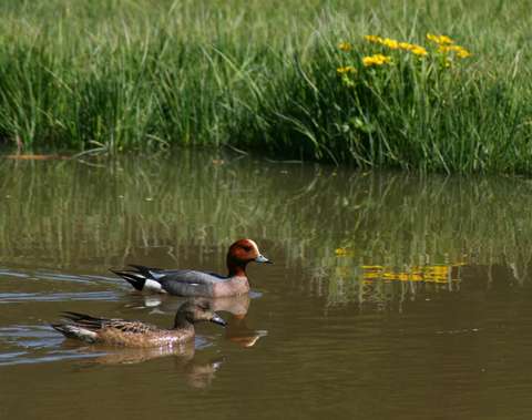
The Finnoo nature trail circles around the wetland and provides an excellent opportunity to see the wide variety of wetland birds inhabiting the area. At Finnoo, you can also see birds up close without a telescope or binoculars. There are two birdwatching towers and signs along the route with information about the local flora and fauna.
Length: 1.6 km
Difficulty: easy (not wheelchair accessible)
Starting point: Hyljeluodontie 3, FI-02270 Espoo
Finnoo nature trail on the Service Map: https://palvelukartta.hel.fi/en/unit/53831(external link, opens in a new window)
You can read more about the Finnoo nature trail and Finnoviken wetland on the Matinkylä-Olarin luontokohteet page (in Finnish).
The Hanikka nature trail takes you to the marine landscapes of the Soukka region. The nature in the area is diverse, ranging from black alder groves to rocky pine forests and spruce-dominated mixed forests.
The route runs through varied terrain on duckboards, through forests and on rocks. You can join the trail at any point and walk just part of it if you like. At times, the path runs on a rock surface. Wetter places are covered with duckboards. The hilltops and rocky shores offer great spots for taking a rest and enjoying a bite to eat.
The trail is best suited for the physically fit and the able-footed, and it is marked with signs. The trail is lined with 14 information boards about the rich birdlife in Kaitalahti, the Bronze Age burial cairns, traces of the Ice Age in nature, and the forest and waterfront environments. The birdwatching tower is an ideal place for aquatic birding.
Length: 6,5 km
Difficulty: medium
Starting point: Matasaarentie 1, FI-02380 Espoo
In addition to Suinonsalmi, the trail can also be reached from Soukka and Soukansalmi, for example. By bus, the trail can be reached from the Suononsalmi, Soukankallio, Vesiniitty, Alakartanonkuja and Alatörmä stops. In addition to the parking area near Suinonsalmi, parking spaces can be found in the parking area of the Hanikka fitness trail.
Hanikka nature trail on the Service Map: https://palvelukartta.hel.fi/en/unit/53830(external link, opens in a new window)
You can read more about the Hanikka nature trail and nearby nature sites on the Espoonlahden luontokohteet page (in Finnish). Along the Hanikka nature trail (item 4.17), you can see sites like the Kaitalahti bay (4.18), Hanikka boulder (4.19), Mätäjärvi bog (4.20) and Soukka ancient shore (4.21). Nearby, you can also find the Hanikka rapakivi granite boulders (4.22) and Hanikka pine (4.23).
Embedded content cannot be displayed
The Karakallio nature trail introduces visitors to the most significant nature sites of the Rastaalanmetsä forest, including the Karakallio herb-rich forest with hazel. The Karakallio nature trail has been created in cooperation with Rastaalan koulu school. The information boards on the trail have a QR code that allows you to see texts and pictures and hear soundscapes produced by the school’s pupils. The nature trail lives and adapts according to the seasons and the pupils’ interests.
The nature trail is approximately 1.2 km long and is marked on the terrain with yellow paint marks. The nature trail is not wheelchair accessible, but part of it follows an easy pedestrian path.
Length: 1.2 km
Difficulty: easy (not wheelchair accessible)
Starting point: Rastaalantie 6, FI-02620 Espoo
You can reach the nature trail from the outdoor routes starting from Rastaalantie or Karakalliontie. The nearest bus stops are Rastasmäki and Karakallionkuja.
You can read more about the Karakallio nature trail, the herb-rich forest with hazel and other nearby nature sites on the Leppävaaran luontokohteet page (in Finnish).
The Oittaa nature trail meanders in the Oittaa stream valley in a nature reserve. The terrain is spruce-dominated, with the coastal forest and black alder mire near Lake Bodom bringing some variation. Trail-side signs contain information about the surrounding nature. The trail is mainly a relatively easy forest path. The rocky slope towards the end is fitted with steps for easier access. The nature trail starts next to the main building of the Oittaa Manor.
Length: 1.5 km
Difficulty: partly challenging
Starting point: Oittaa Recreation Centre, Kunnarlantie 33–39, FI-02740 Espoo
Oittaa nature trail on the Service Map: https://palvelukartta.hel.fi/en/unit/53826(external link, opens in a new window)
You can read more about the Oittaa nature trail and nearby nature sites on the Bodomin luontokohteet page (in Finnish). The nature trail (item 10.2) circles mainly in the nature reserve of the Oittaa stream valley (10.1), and nearby you can also find, for example, the Bodom black alder mire (10.3) and Oittaa glaciated rock (10.4).
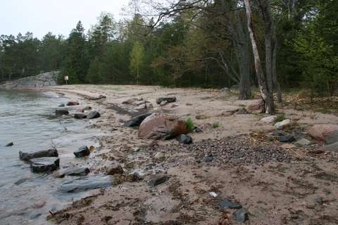
The scenery on Pentala Island ranges from idyllic archipelago courtyards to wooded areas and a fine sandy beach. The only nature trail in maritime Espoo presents the unique archipelago nature of Espoo. The route starts in the courtyard of the Pentala Archipelago Museum and runs back to the museum via Diksand beach. The nature trail is marked on the trees with yellow marks.
Length: 2.3 km
Difficulty: easy (not wheelchair accessible)
Starting point: Courtyard of the Pentala Archipelago Museum, Pentala 44, FI-02380 Espoo
In the summer, there is scheduled archipelago boat traffic to Pentala Island. For those arriving in their own boat, the Archipelago Museum’s pier offers 10 docking places.
Pentala nature trail on the Service Map: https://palvelukartta.hel.fi/en/unit/57427(external link, opens in a new window)
You can read more about the Pentala nature trail and nearby nature sites on the Saariston luontokohteet page (in Finnish). The Pentala nature trail (item 5.2) runs through the Pentala nature reserve (5.1.) and leads past the former Pentala fields (5.7) and Lake Pentalanjärvi (5.5) to Diksand beach (5.3).
The Sorlampi nature trail meanders in varying forest landscape mainly inside a nature reserve. The area is characterised by steep cliffs, stream valleys and occasional, primeval forest type coniferous stands. Along the trail, you get to take a look at the Sorlampi glacial pothole and the Hiidenpesä cave. There are also other interesting geological sites along the trail.
If you wish, you can extend the Sorlampi route by two kilometres by also taking the Laihalampi route along the way.
Length: 5 km
Difficulty: medium
Starting point: Nuuksiontie 30, FI-02820 Espoo or Nuuksion Ulkoilumaja, Nuuksionkuja 2, FI-02820 Espoo
The nearest bus stop is Siltaniitynlaita. The Hakjärventie and Brobackanpiha bus stops are about 500–600 metres from the southern end of the nature trail.
Sorlampi nature trail on the Service Map: https://palvelukartta.hel.fi/en/unit/53829(external link, opens in a new window)
You can read more about the Sorlampi nature trail and nearby nature sites on the Nuuksion luontokohteet page (in Finnish). The nature trail (item 13.46) mainly runs around the Hakjärvi nature reserve (13.45), going past, for example, the Lajalampi herb-rich forest with hazel (13.47), Sorlampi glacial potholes (13.48), Hiidenpesä cave (13.49), Hackjärvsmossen swamp (13.50), Brobacka moraine threshold (13.51) and Brobacka rapakivi granite boulder (13.52).
The Tikankierros nature trail circles around typical Espoo Central Park forest terrain, where the conditions vary from rugged rocks to lush hollows. Along the route, there are two meadows classified as traditional landscapes. In addition, the two glacial potholes of Central Park are located near the nature trail. The path to the potholes is signposted.
The nature trail intersects with outdoor routes in several places, so you can easily walk just part of it. It is signposted and has five information boards explaining the rich wildlife in Central Park. The nature trail follows old forest paths and is challenging in parts. There are duckboards in the wetter sections to make it easier to proceed. The rocks along the nature trail provide nice places for eating snacks and taking a rest.
Length: 3 km, but you can walk just part of it if you like.
Difficulty: partly challenging
Starting point: Alamäentie 3, FI-02760 Espoo
The parking area and the nearest bus stops (Soliseva or Riimukallio) are about 700 metres away from the beginning of the nature trail.
Tikankierros on the Service Map: https://palvelukartta.hel.fi/en/unit/53827(external link, opens in a new window)
You can read more about the Tikankierros nature trail and nearby nature sites on the Keskuspuiston luontokohteet page (in Finnish). Along the Tikankierros nature trail (item 3.3), you can see sites like Ritva’s Forest (3.1), the Central Park nature reserve (3.2), Central Park glacial potholes (3.4), Mössenkärr nature reserve (3.5) and Rönnängen meadow (3.6).
The Tremanskärr nature trail offers many things to see and experience. The area is characterised by its rocky forests with spruce valleys, a natural raised bog and the Kurkijärvi forest pond. The route through the raised bog is 1.2 km long and the Kurkijärvi route 1.5 km. The total length of the nature trail is about 2.5 km.
The trail runs largely in a nature reserve. The information boards present the nature in Northern Espoo and the Tremanskärr raised bog. The benches along the trail are good places for eating snacks and taking a rest. The bog sections have duckboards, and there are steps near Kurkijärvi. The route mainly follows the paths and is challenging in some places. The duckboards can be slippery, especially in damp conditions.
Length: 2.5 km, but you can walk just part of it if you like
Difficulty: partly challenging
Starting point: Vihdintie 65, FI-02970 Espoo
The nearest bus stop is Kalajärvi. You can reach the nature trail via the fitness trail. The Kalajärvi fitness trail parking area is approximately 1.5 km away from the start of the nature trail.
Tremanskärr nature trail on the Service Map: https://palvelukartta.hel.fi/en/unit/53834(external link, opens in a new window)
You can read more about the Tremanskärr nature trail, Tremanskärr and Kurkijärvi nature reserves and nearby nature sites on the Kalajärven luontokohteet page (in Finnish).
The nature trail meanders around the old manor park, presenting old high-society manor garden culture and lush, herb-rich vegetation. Along the trail, you can find more than 30 domestic or foreign tree or shrub species, which are identified by signs.
There are two trails about 1 km long running around the nature reserve. The paths are easy to walk and accessible with prams.
Length: 2 km
Difficulty: easy (not wheelchair accessible)
Starting point: Kuninkaantie 43, FI-02940 Espoo
Träskända is easily accessible by public transport. The nature trail is a short walking distance away from the stops of Träskända Manor (Träskändan kartano), Träskändanristi, Auroranportti, Heiniemenpolku and Tammihaantie.
Träskända nature trail on the Service Map: https://palvelukartta.hel.fi/en/unit/53823(external link, opens in a new window)
You can read more about the Träskända nature trail and nearby nature sites on the Laaksolahden luontokohteet page (in Finnish). The Träskända route (item 9.19) runs through the Träskända nature reserve (9.18), going past, for example, the over 300-year-old Träskända oak (9.20) and one of Finland’s tallest little-leaf linden trees (9.21). There is also the Träskända hardwood forest (9.17) nearby.
There are several nature trails around Villa Elfvik that provide information about the nature and history of the area for people of all ages. Read more on the Nature trails around Villa Elfvik page.
The seven information boards of the Nature Sanctuary nature trail present the history of the old villa, the nature of the area and the Laajalahti nature reserve. The 700-metre long route is accessible for prams and wheelchairs during snow-free times. The lower platform of the Elfvik birdwatching tower is accessible. Learning materials relating to the nature trail have been made for children of different ages. You can also explore the tree species on the trail with the help of the Tree Species Trail (Puulajipolku) booklet. In winter, you can walk the trail with children using the On a Hare’s Trail material.
Nature House Villa Elfvik also serves as a starting point for other short nature trails. The Väinö the Crow nature trail for children dives into the old forest. Trails for adults are the History of the Village Landscape (Kylämaiseman historia) nature trail and the History Herbarium (Historiakasvio) trail. The one-kilometre-long mobile nature trail, Journey with Flying Squirrel, introduces both adults and children to the life of Espoo’s symbol animal.
Starting point: Courtyard of Nature House Villa Elfvik, Elfvikintie 4
Villa Elfvik is easy to reach by bus. Along Ring I, the Kurkijoentie bus stop is about 750 metres away from Nature House Villa Elfvik. The parking area along Elfvikintie road also has a city bike station.
Nature Sanctuary nature trail on the service map: https://palvelukartta.hel.fi/en/unit/53822(external link, opens in a new window)
You can read more about Villa Elfvik’s nature trails, the Laajalahti nature reserve and nearby nature sites on the Tapiolan luontokohteet page (in Finnish).
A short and easy trail runs alongside the Nupuri birdwatching tower, following the southern edge of Lake Nupurinjärvi. The nature trail mainly consists of a wide boardwalk, but also includes some forested sections and hazel bushes. There are no information boards along the route. The total distance when returning to the starting point is approximately 1.5 kilometers.
Length: 0.7 km
Difficulty: easy (not accessible)
Starting point: Nupurinkartanontie, 02820 Espoo or Nupurinkalliontie 16, 02820 (no parking available)
Other nature trails in Espoo
The nature trail meanders around Fiskarsinmäki, whose herb-rich forest forms the core of the 25-hectare Espoonlahti nature reserve. Halfway through the route is the birdwatching tower, where you can admire the diverse wetland birdlife of Espoonlahti.
The Espoonlahti nature reserve comprises the herb-rich forest and meadow areas of Fiskarsinmäki and part of the reed bed on the shore. The area is part of the national herb-rich forest conservation programme, and the Espoonlahti coastal meadow has been classified as a traditional landscape. In addition to the nature trail, the area has an extensive network of paths, which makes it easy to increase the length of the excursion.
Length: 1 km
Difficulty: easy (not wheelchair accessible)
Maintained by: Metsähallitus (Metsähallitus feedback service: www.metsa.fi/en/feedback/(external link, opens in a new window))
Starting point: Lasilaakso 20, FI-02780 Espoo
Fiskarsinmäki nature trail on the Service Map: https://palvelukartta.hel.fi/en/unit/53633(external link, opens in a new window)
You can read more about the Espoonlahti nature reserve and coastal meadow on the Kauklahden luontokohteet page (in Finnish).
Embedded content cannot be displayed
The Glimsinjoki river bank trail, designed and built by the Pro Espoonjoki association, runs some 2 kilometres from Träskända park to Glims Farmstead Museum. The trail mainly follows a forested path along the river, but makes short detours to a dirt road in Ingas and asphalt when reaching Turuntie. The river can be crossed by bridges in Ingas and Jorvinkoski.
The trail is not marked on the terrain or fitted with bridges or duckboards. During spring floods, parts of the trail may be submerged in water.
There are no information boards along the trail, but it is possible to explore the riverside nature and streams with the help of the Glimsinjoki river guide (below). The guide presents 14 nature sites and cultural attractions along the route. It also includes a map of the area. The guide was prepared by the Pro Espoonjoki association.
Length: 2 km
Difficulty: medium
Maintained by: Pro Espoonjoki association
Starting point:
Träskända Manor: Kuninkaantie 43, FI-02940 Espoo
Glims Farmstead Museum: Glimsintie 1, FI-02740 Espoo
You can read more about the Glimsinjoki nature trail and nearby nature sites on the Laaksolahden luontokohteet page (in Finnish). The nature trail (item 9.22) starts from the Träskända nature reserve (9.18) and runs through the nature reserves of the Jahtimetsä herb-rich stream valley (9.23), Ingaksenmetsä forest (9.24) and Kvarnbyån herb-rich stream valley (9.25). There are also other interesting nature sites around Träskända Manor, and the Glimsinjoki river bank trail is easy to combine with the Träskända nature trail.
The nature trail between Lake Hannusjärvi and Länsiväylä is maintained by the Espoo Hannusjärvi preservation society. The trail winds in the midst of spruce-dominated coniferous forests, rugged pine stands, wetland hollows and Hannusjärvi wildwoods. There are also a number of geological sites found along the trail. Trail-side signs contain information about the surrounding nature. The route follows old paths, but is in parts challenging and very wet during rain. The trail is colour coded to show the level of difficulty and marked with tapes.
Length: 3.5 km
Difficulty: partly challenging
Maintained by: Espoo Hannusjärvi preservation society
Starting point:
From Iivisniemi: Hannusranta 14, FI-02260 Espoo
From Hannusjärvi: Hannuntie 32, FI-02360 Espoo (no parking)
The nearest bus stop is Iivisniemi. In addition, the trail can be reached by walking a short distance from the Koulumäki and Espoonlahdensolmu bus stops.
You can read more about the Hannusmetsä nature trail and nearby nature sites on the Espoonlahden luontokohteet page (in Finnish).
Jupperi Detached House Association has restored a nature trail in the Kaipio Forest in Jupperi. The trail is marked with blue signs in the terrain. Along the route, there are 11 information boards with facts about the local nature and activities suitable for the whole family.
Length: 1.2 km
Difficulty: partly challenging terrain
Maintained by: Jupperi Detached House Association
Starting point: Tammipääntie 33, 02730 Espoo
Read more on the Jupperi Detached House Association’s website: https://www.jupperi.fi/yhdistys/luontopolku/(external link, opens in a new window) (in Finnish)
The nature trail starts in the yard of the Tammenterho cottage at Tammipääntie 33. There is parking space for several cars in the yard. The nearest bus stop is Rinnetie.
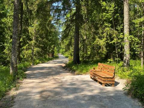
Korennon kierros is an accessible nature trail located in Lakisto. It is easy to reach by bus or car, and both ends of the trail have drop-off points and plenty of free parking. The trail is 610 meters one way and is mostly accessible, with some sections classified as demanding accessible. These more demanding parts can be completely avoided. The trail surface is compact crushed stone and about 2 meters wide throughout.
At the rest area, there is a half-shelter, two campfire sites, and two picnic tables. Near the river, there is a viewing platform with benches, and there are also resting spots along the trail.
The trail winds through beautiful forest scenery with rocky areas and follows the Lakisto River. The name "Korennon kierros" comes from the dragonflies that thrive in the area – up to 22 species have been identified. The trail complements the accessible recreational services in Lakisto, which already include an accessible disc golf course and an accessible playground.
Length: 610 meters one way, approx. 1.2 km total
Difficulty: accessible, partly demanding accessible
Maintained by: The Deaconess Foundation
Starting point: Accessible route start: Alajyrkäntie, 02980 Espoo. Demanding accessible trail start: Rinnekodintie 6, 02980 Espoo
Read more on the Deaconess Foundation’s website www.hdl.fi(external link, opens in a new window) (in Finnish)
The trail is maintained by the Deaconess Foundation. Its construction has also been funded by Rinnekodit, the Regional State Administrative Agency for Southern Finland, the Wellbeing Espoo program, the City of Espoo’s Sports Unit, Metsä Group, Rinnetuki ry, Lions Club Espoo North, and Partioaitta.
A 2.9-kilometer trail in the Laajalahti nature reserve runs along the shoreline from the Villa Elfvik Nature House to Otaniemi. Laajalahti is especially worth visiting in spring, when thousands of birds arrive to rest in the bay. From the Maari birdwatching tower and the Laajalahti viewing platform, you can observe nature without disturbing it. There are no information boards along the trail.
Most of the route consists of narrow boardwalks. It can be walked with regular outdoor shoes, but the boardwalks may be slippery when wet. The trail can be accessed from the Villa Elfvik Nature House and from Konemiehentie in Otaniemi.
Length: 2.9 km
Difficulty: easy (not accessible)
Maintained by: Metsähallitus (Feedback: www.metsa.fi/palaute(external link, opens in a new window))
Starting points: Villa Elfvik Nature House, Elfvikintie 4 or Konemiehentie 6, 02150 Espoo
Villa Elfvik is easily accessible by bus. From the Kurkijoentie bus stop along Ring I, it’s about 750 meters to the nature house. There is also a city bike station at the parking area along Elfvikintie. On the Otaniemi side, the trail is easily reached by metro and light rail line 15. The nearest metro station is Aalto University, and the nearest tram stop is Aalto University (M), both about 700 meters from the trailhead.
Located in the Luukki outdoor recreation area, the nature trail provides information on the forest nature of the area, its management and protection, and the local history of the area. The trail is marked with pine cone symbols, and there are two path options to choose from: 6 or 9 km nature trails. The path follows outdoor recreation routes and is easy to walk with the exception of a few steep hills. There are several cooking areas and camping spots in the area.
Several small ponds and swamps increase the diversity of nature in the Luukkaa outdoor recreation area. The forests are diverse, too, ranging from barren rocks to small herb-rich forests. In the north-eastern and north-western parts of Luukkaa, there are extensive old-growth forest areas kept in their natural state.
Read more on the City of Helsinki website: Luukki outdoor recreation area(external link, opens in a new window)
Length: 6–9 km depending on the route chosen
Difficulty: easy (not wheelchair accessible)
Maintained by: City of Helsinki
Starting point: Luukki parking area, Luukintie 33, FI-02970 Espoo
You can read more about the Luukki nature reserve and nearby nature sites on the Velskolan luontokohteet page (in Finnish).
Maahisenkierros is a 2 km ring route that is also suitable for prams and wheelchairs with an assistant. The trail runs along the edge of the Solvalla sports field, then climbs into the forest and leads the traveller further to a rocky pine forest and the observation platform, which opens up a magnificent view over Lake Pitkäjärvi in Nuuksio. There is also a rest stop along the trail.
Maahisenkierros starts from the Finnish Nature Centre Haltia’s courtyard at the southern end of the Solvalla sports field.
Read more about Maahisenkierros on the Metsähallitus website(external link, opens in a new window) (in Finnish).
Length: 2 km
Difficulty: challenging wheelchair route
Maintained by: Metsähallitus (Metsähallitus feedback service: www.metsa.fi/en/feedback/(external link, opens in a new window))
Starting point: Finnish Nature Centre Haltia, Nuuksiontie 84, FI-02820 Espoo
Nahkiaispolku is a 2 km ring route with information boards about forest restoration in Nuuksio National Park. The trail is marked with pine cone symbols. The trail begins and ends with a steep hill, but the rest is quite even. There are also duckboards and steps along the way.
The trail sets off from the Haukkalampi parking area.
Read more on the Metsähallitus website: www.luontoon.fi/en(external link, opens in a new window)
Length: 2 km
Difficulty: medium
Maintained by: Metsähallitus (Metsähallitus feedback service: www.metsa.fi/en/feedback/(external link, opens in a new window))
Starting point: Haukkalampi parking area, Haukkalammentie 32, FI-02820 Espoo
You can read more about the Nahkiaispolku nature trail and nearby nature sites on the Nuuksion luontokohteet page (in Finnish). Along the Nahkiaispolku nature trail (13.8), you can find, for example, the Purola meadow (13.9), Nuuksionpää meanders (13.10), Myllypuro rapids (13.11) and Haukkalammenpuro rapids (13.12).
The Olari health nature trail is a nature trail located in Kokinmetsä, Espoo Central Park, along which you will find several natural elements that have a positive effect on your health. Along the trail of approximately 2.5 km, there are eight checkpoints with three separate exercises each. The exercises on the information boards guide the hikers to observe, learn and experience nature’s many health effects from mental well-being to improved physical condition. For those seeking the health benefits of nature, the exercises along the path offer a break from everyday life, helping them to connect to the sensations of the mind and body.
The health nature trail can be followed in both directions, and the checkpoints do not have to be visited in order. The exercises on the information boards are provided in three languages. The health nature trail intersects with outdoor routes in several places, so you can easily walk just part of it. The nature trail is partly challenging, with tree roots, duckboards, steps and elevation variations. 360-degree photographs of the information boards on the health nature trail are available in the Espoo Map Service: kartat.espoo.fi(external link, opens in a new window)
Length: 2.5 km, but you can walk just part of it if you like.
Difficulty: partly challenging
Maintained by: Olari-seura association and Espoo Public Works Department
Starting point: Kuusikallionkuja 2, FI-02210 Espoo (parking area)
The parking area at the intersection of Ylismäentie and Olarinkatu is about 100 metres away from the beginning of the nature trail. The nearest bus stop is Alaportti, and the route can also be reached from the Ylismäenristi bus stop.
You can read more about the Olari health nature trail and nearby nature sites on the Keskuspuiston luontokohteet page (in Finnish).
Downloadable files
Embedded content cannot be displayed
Päivättärenpolku is a 1.4 km nature trail that circles around the Finnish Nature Centre Haltia. The nature trail is marked with pine cone symbols and is challenging in parts. The trail has many elevation differences and steep inclines. The information boards on the nature trail present the nature of Nuuksio National Park in an interesting way.
Along the path is the reservable Aarnituli campfire site, which can be reserved at the Haltia information desk. The campfire site can be reserved free of charge by schools and day-care centres.
Read more on the Metsähallitus website: www.luontoon.fi/en(external link, opens in a new window)
Length: 1.4 km
Difficulty: partly challenging
Maintained by: Metsähallitus (Metsähallitus feedback service: www.metsa.fi/en/feedback/(external link, opens in a new window))
Starting point: Finnish Nature Centre Haltia, Nuuksiontie 84, FI-02820 Espoo