Detailed planning of the Kyläseppä and Storhemt areas
Land use reviewsMatinkyläTapiolaPlanning for Kyläseppä and Storhemt had been carried out under the Suurpelto IV and Suurpelto V detailed plans. In further planning, it has become important to consider changes in the urban structure in the regional plan and to improve the feasibility of the detailed plans. In 2020–2021, to update the goals of the areas’ detailed plans, the city prepared the Sepänkallio-Storhemt outline plan. Detailed planning for the area will take place in phases. It is our goal that the planning is carried out in cooperation with the implementation projects. The district plan will serve as a guide for detailed planning.
Plan name
Sepänkallio-Storhemt district plan
Location
SuurpeltoBefore the detailed plans, the city prepared the Suurpelto-Kehä II partial master plan (City Board, 24 May 2005), the base solution of which included in the master plan for southern Espoo. In 2012, after goal setting and several rounds of public review, the City Planning Committee sent the proposed detailed plans for Suurpelto IV and Suurpelto V to the approval processes of the City Board and the City Council. In 2019, after the land use agreements, which were required to approve the plan proposals, were not signed, the City Board returned the Suurpelto IV and Suurpelto V detailed plans to the preparation process.
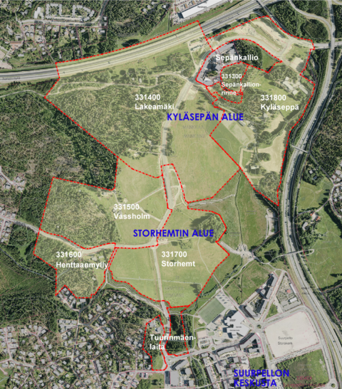
The detailed plans for the sub-areas have been given new names with historical significance and preliminary boundaries. Status in summer 2025:
- Currently, the detailed plans for the Sepänkallionrinne, Lakeamäki and Kyläseppä areas on the northern side in Kyläseppä have been initiated.
- On the southern side in Storhemt, the detailed plans for the Vassholm, Henttaanmylly and Storhemt areas have been initiated.
It is possible to further divide the detailed plans into smaller sections. Of the detailed plans in the outline plan area, 330800 Kyläsepäntie, 331200 Sepänkallio and 331100 Tuurinmäenlaita are valid (in 5/2025). The city has already built the collector streets, which enable the construction stages in the area, the core municipal infrastructure network and regional stormwater processing in the area. The area has also been connected to the public transport network, and the first residential blocks in Sepänkallio will be completed in 2025.
In the initiated planning areas, we are currently undergoing block planning and general planning for the municipal infrastructure. The City Planning Committee will initiate a new round of public review for the proposed detailed plans and seek feedback from both residents and public authorities. After the public review, the committee will carry out the necessary checks, after which they are submitted into the approval process. The detailed plans include land use agreements, which the plot unit negotiates during the City Board’s stage.
Aila Valldén
Architect, detailed planning (Suurpelto, Northern Espoo)+358 43 8251919aila.vallden@espoo.fiTekniikantie 15, OtaniemiSirpa Sivonen-Rauramo
Area Architect, Detailed Planning+358 50 3475494sirpa.sivonen@espoo.fiTekniikantie 15, OtaniemiSalla Mäkelä
Transportation Engineer, Traffic and transportation planning for detailed plans+358 40 6369068salla.makela@espoo.fiTekniikantie 15, Otaniemi