On display: Street plans related to Maarinsolmu
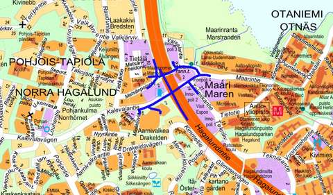
Streets and trafficTapiolaThe existing light-controlled at-grade intersection on Ring Road I at Kalevalantie will be converted into the Maarinsolmu interchange. The street plans show the measures to be taken in the street network in connection with the construction of Maarinsolmu. The street plans will be available for public review from 2 March to 16 March 2026.
Location
Kalevalantie, Mielikinviita, Hopealehdonpolku, Maarintie, Maarinrannantie, Tekniikantie, Maarinporras, Metsänpojankuja, Metsänneidonpolku, Kalevalantie alikulkukäytävä, MaarinsolmunsiltaPhase
Proposal phase
Ring Road I is an important ring road in the Helsinki Metropolitan Area and the busiest road in Finland, connecting, for example, motorways leading to West Harbour and the Helsinki region. The aim of the construction of Maarinsolmu is to improve the reliability and safety of the transport system on the important ring road.
The Kalevalantie intersection serves the traffic not only of Tapiola, but also of the emerging campus area of Otaniemi and the increasing land use of the metro and light rail hub. According to traffic forecasts, the volume of traffic on Ring Road I will continue to increase. Traffic flow is already sensitive to disruption and at peak times there are long queues at critical sections every day. An accident-prone at-grade intersection also creates unforeseen disruptions that can cause long delays even during off-peak hours. Another current problem is the risk of flooding in the area, with lanes having to be closed when the water level rises by about one metre from its baseline.
The measures are based on the road plan for Ring Road I between Kalevalantie and Turunväylä (National Road 1), which was completed in 2017, and the road plan for the Maarinsolmu section, which was approved after the change to the local detailed plan became law in 2024.
The main planning measures in the road plan are:
- The existing light-controlled at-grade intersection will be converted into an interchange.
- The existing crossing for pedestrians and cyclists on Kalevalantie will be converted into an underpass.
- The pedestrian and cycle bridge over Ring Road I will be renovated.
- A flood barrier structure will reduce the risk of sea flooding on Ring Road I.
The street plans show the measures to be taken in the street network in connection with the construction of Maarinsolmu. Kalevalantie, Maarintie and Tekniikantie are the existing main roads serving the area and also serve public transport. Maarinrannantie is a busy street in the workplace district, with a light rail line running through it. Maarinporras is part of the bicycle network Baana, which serves cyclists and pedestrians going between Otaniemi and Laajalahti and Otaniemi and Tapiola.
The streets will be improved to cater for the changing situation resulting from the interchange. There are several lanes on Kalevalantie and Maarintie in the area of the interchange between Tietäjäntie and Maarinrannantie. The cross-section is at its widest at the Maarinsolmu intersection bridge, where the usable width is 34.5 metres. A new separate pedestrian and cycle path linking Tapiola and Otaniemi will be created on the southern edge of the bridge. There are five light-controlled and channelled intersections on Kalevalantie and Maarintie: at the western end of the street planning area, the four-way intersection of the ABC/HOAS plots, at the eastern end, the intersections of Maarintie and Tekniikantie/Maarinrannantie, and the ramps.
The construction of Maarinsolmu will improve traffic flow on Ring Road I, reduce sensitivity to disruption and improve traffic safety. The network of pedestrian and cycle routes will be complemented and made safer. Conditions for public transport and land use development opportunities will be improved.
The estimated cost of improving the Maarinsolmu intersection is approximately EUR 59.1 million (Cost index of civil engineering works 2020 = 100;145). In the MAL agreement, it has been agreed that the State's share of the costs will be a maximum of EUR 33.7 million and the City of Espoo's share a maximum of EUR 25.4 million.
Construction of Maarinsolmu is expected to start in spring 2027.
The street plans will be available for public review from 2 March to 16 March 2026.

Contact information
Customer Service of the Urban Environment
+358 9 81625100Tekniikantie 15, 02150 EspooPhone service: Mon–Fri 10:00–15:30
Otaniemi Service Point: Mon–Fri 8:00–15:30
Urban Environment Customer Service can advise you on matters, such as
✔ streets and traffic
✔ parking control
✔ parks, green spaces and forests
✔ land use planning
✔ construction and land use permits
Give feedback: Link to survey(external link, opens in a new window)