Nissinpuisto street and Hepmortinreitti route
Streets and trafficKauklahtiThe City of Espoo’s Public Works Department finished the street plans for the Nissinpuisto street and its parking area and the park plans for the Hepmortinreitti park pathway. The plans can be found on this page under “Plan material” (in Finnish) The Technical Services Committee approved the plans on 13 September 2023.
Phase
Legally valid
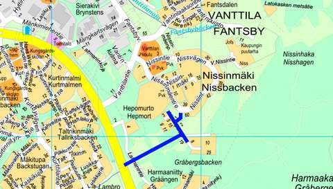
The aim for the Nissinpuisto street planning is to improve the street's traffic and safety related solutions. A turning point for passenger cars will be planned in the northern end of the street. A public parking area will be planned for the area marked in the local detailed plan.
A park route will be planned for the park area between Nissinpuisto and Laitmanintie streets. In the east the route will continue from where the existing Nissinlaaksonreitti route ends at the Nissinpuisto street and in Laitmanintie it will connect to the Kauklahdenväylä underpass. The route will be covered with stone ash, it will be 3.5 metres wide, and illuminated over its entire length
The draft plans were available for comments in the Ota kantaa service between 15.5.-28.5.2023.
In accordance with the Land Use and Building Act, the street and park plan proposals were finalised after the draft stage and were presented in public from 31.7.-14.8.2023 and then submitted to the Technical Services Committee for processing. The parties concerned were notified by letter of the presentation in public.
Next the street and park plans will be turned into building plans. Construction will take place in 2024.
Contact information:
Customer Service of the Urban Environment
+358 9 81625100Tekniikantie 15, 02150 EspooPhone service: Mon–Fri 10:00–15:30
Otaniemi Service Point: Mon–Fri 8:00–15:30
Urban Environment Customer Service can advise you on matters, such as
✔ streets and traffic
✔ parking control
✔ parks, green spaces and forests
✔ land use planning
✔ construction and land use permits
Give feedback: Link to survey(external link, opens in a new window)