How to get to know the master plan
The master plan is an extensive and demanding document. To make it easier for you to participate, we have put together some tips and three participant paths. The paths offer different perspectives on the plan and guide you step by step through the process of studying the plan material and giving your opinion.
What the master plan contains
The plan material consists of three parts:
- The plan map showing the different areas, zones, roads and routes.
- Plan regulations describe in more detail what the symbols on the plan map mean. They indicate the main use of the area.
- The plan report provides the background and grounds for what is set out on the plan map and in the plan regulations.
To understand the plan map, you should read at least the plan regulations and preferably also the plan report.
The plan report and the plan regulations form the legally binding part of the master plan. This means that the city can undergo detailed planning and be built within the limits of the master plan once the master plan has entered into force.
Other materials include
- different studies that have been carried out as a basis for planning
- theme maps describing the plan solution from a particular perspective
All materials can be found on the plan web page. Go to the plan web page.
Three things to help you better understand the master plan
1. A master plan map is a general plan
The master plan map is drawn at a fairly rough level. It gives an overview of the city's land use in 2060. The master plan map only designates the main use of the area, for example housing. In addition to the main use, there are usually other activities in the area such as transport routes, services and recreational areas.
The areas marked in the master plan are extensive. They do not take into account, for example, plot boundaries. It is therefore not worth studying the map too closely. For example, the fact that the edge of a green area seems to encroach upon your plot does not mean that your plot is actually encroached upon in any way.
2. The plan contains a wide range of regulations
The plan regulations apply to the areas indicated in the plan. There may be several overlapping markings on the plan map. For example, the map may indicate an important cultural environment and at the same time the main use of the area may be residential. If the area is subsequently planned, for example by means of a local detailed plan, all markings must be taken into account.
The plan also contains general regulations that apply to the whole planning area These can be found at the beginning of the plan regulations.
3. The master plan does not lead to construction
The master plan describes what can be planned and built in the future, and what must be preserved, such as key recreational areas and cultural environments. For example, space must be reserved well in advance for rail connections, so that they can be built in the future if they are needed.
A more detailed level of planning than master planning is local detailed planning. The master plan does not therefore in itself lead to changes.
How to read the plan map and regulations
The map shows the areas, zones, roads and routes. There are no place names on the map, so it may take a while for you to get your bearings. Look for familiar features on the map such as major existing transport routes and rail tracks, centres, water bodies and green spaces.
All plan symbols are explained in the plan regulations. They show what future uses may exist in different areas and how they should be taken into account in their development. Read the plan regulations alongside the map.
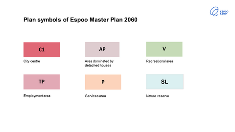
The areas are marked with colour code and a letter identifier. For example,
- centres of different sizes are marked in red with the identifier C1, C2 or C3, which indicate the size and level of service of the centre
- housing areas are marked in different shades of brown and with a letter code indicating the type of area
- the map also includes areas for services, jobs, recreation and nature conservation.
The lines indicate different roads and routes such as
- rail, tram and metro lines
- outdoor recreation route
- ecological and green connections linking natural and recreational areas
The zones are marked with different types of rasters such as squares and lines. These include, for example, development zones for central areas and development zones related to public transport.
The map also includes areas with a valid component master plan. In these areas, the regulations of the old master plan remain in force. The symbols on this map are new more detailed additional information that can be used in further planning of the area, such as local detailed planning. However, the symbols in these areas do not have legal effect.

City path
Explore the development of Espoo as a whole. On this path, you can focus in particular on the city's transport network, centres and housing.
Where will we locate new homes as our population grows? What kind of centres and housing areas do we want? A growing population will also increase mobility needs and traffic. How do we ensure that mobility is smooth and sustainable?
Learn more about the material
- Find the existing main roads and rails on the plan map. Please note that the existing roads are marked in the same way as the new solutions proposed in the plan.
- Find on the map the city centre areas: existing and proposed new areas that would be located along the rail tracks.
- Surrounding the central areas are residential areas where construction and services are at a lower level than in the central areas.
- From the plan regulations, find out what these symbols mean
- Take a look at the residential theme map and the traffic theme map. They will help you to understand the master plan in relation to these themes.
- Read the plan report, to find out what is said about these themes.
Consider for example:
- Does the draft plan meet the objectives of the plan. You can read the targets here.
- Do you think that the way the draft plan suggests locating housing in and around centres is good?
- Are the proposed public transport lines adequate and in the right places?
Share your views
If your opinion relates to a particular map symbol or location, it is often easiest to give your opinion on the map platform. There is also a text field on the map platform where you can give general feedback.
However, you can also send your opinion in writing to the Registry Office. In that case, please describe the exact location if your feedback concerns a specific place or symbol. Read the instructions here.
Local environment path
Take this path if you want to explore and comment on your own neighborhood or another area that is important to you.
Learn more about the material
- Find your area on the plan map. If you are using a digital map platform, the easiest way to find the area you are looking for is to enter the address in the search field. Zoom in and out on the map to see the area in the right size.
- From the plan regulations, find out what the area’s symbols mean.
- Please note that the master plan is made at a rough level. The area markings do not follow exactly the boundaries of the plots, for example. A planning marking may fall on your side of your plot, but that does not mean any changes to your plot. That is why it is not worth zooming in too closely on a map.
- The plan map shows the main purpose of each area, for example housing. In addition to the main use, there are usually other activities in the area, such as transport routes, services and recreational areas.
- If there is an existing component master plan, its regulations remain in force. The Espoo Master Plan 2060 is only indicative in these areas.
- Read the plan report for more information about this area.
Form your opinion
Consider for example:
- To what extent should the current uses of the different areas be maintained in the future?
- What changes might the master plan bring to the current situation in the area?
- What good would come from the changes? It is worth mentioning these so that they are kept in mind when the plan proposal is prepared.
- In what respects do you disagree with the draft and why?
Share your views
If your opinion relates to a particular map symbol or location, it is often easiest to give your opinion on the map platform. There is also a text field on the map platform where you can give general feedback.
However, you can also send your opinion in writing to the Registry Office. In that case, please describe the exact location if your feedback concerns a specific place or symbol. Read the instructions here.
Theme path
Take this path if you are particularly interested in a certain theme such as nature and recreation, the cultural environment or livelihoods.
Learn more about the material
- Set off on a theme map. Maps can be found, for example, on the following themes:
- Livelihoods 2060
- Nature and recreation 2060
- Cultural environments 2060
- A theme map summarises the main issues related to its theme at city level. The map is not legally binding but it will help you to orientate yourself with the plan material. You can find the theme maps in the appendices to the plan.
- Take a look at the plan regulations and see what kind of symbols are associated with the theme you have chosen. Examples of nature and recreation symbols include recreation areas, nature reserves, outdoor trails and green connections.
- Open the plan map and look for these symbols on the map. Please note that the master plan map only specifies the main use of each area. This means that, for example, local nature, recreation and services are not shown on the map. Only the largest and most significant areas reserved for a specific use are shown.
- The plan report describes how the different themes have been weighed up in the planning process and why this solution has been proposed.
- The preparation of the plan has also produced studies on various themes. You can also familiarise yourself with these if you like.
Consider for example:
- How well has the theme been taken into account in the draft plan?
- Have a suitable number of areas been reserved?
- Are they in the right places?
- What is good about the draft in terms of this theme? It is worth mentioning these matters so that they are kept in mind when the plan proposal is prepared.
- In what respects do you disagree with the draft? Why?
Share your views
If your opinion relates to a particular map symbol or location, it is often easiest to give your opinion on the map platform. There is also a text field on the map platform where you can give general feedback.
However, you can also send your opinion in writing to the Registry Office. In that case, please describe the exact location if your feedback concerns a specific place or symbol. Read the instructions here.