Street and park plan for the southern part of Lasihytti
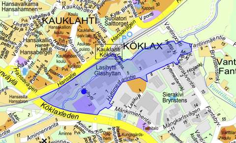
Streets and trafficKauklahtiThe Lasihytti detailed plan entered into force on 26 March 2025. The Public Works Department has continued the planning of the street and park areas. The planning area covers the area between the Espoonjoki river and Hyttimestarintie, as well as the area between the northern side of Espoonjoki and the railway, from Kauklahdenväylä to the Hansaportti underpass.
Phase
Design
You can view and comment on the draft plans through the Otakantaa website between 19 May and 2 June 2025 at www.otakantaa.fi(external link, opens in a new window). The draft plans will also be presented during a resident walk focused on park areas on 21 May 2025, from 17:00 to 18:30. The meeting point is in front of the red pumping station building, located between the K-Supermarket and the river at Lasihytti 2b. The walking route is accessible and approximately 1.5 km long.
The aim is to make the plan proposals available for public review from 6 October to 20 October 2025 and subsequently submit them to the Technical Services Committee for approval. The ELY Centre is processing a protection application for the arched steel buildings built by Slev located in the planning area. A decision is expected in May.
We have collected some planning vocabulary into a glossary to help you. You can find the glossary on the Espoo website by searching ”Street and park planning glossary”.

Contact information
Customer Service of the Urban Environment
+358 9 81625100Tekniikantie 15, 02150 EspooPhone service: Mon–Fri 10:00–15:30
Otaniemi Service Point: Mon–Fri 8:00–15:30
Urban Environment Customer Service can advise you on matters, such as
✔ streets and traffic
✔ parking control
✔ parks, green spaces and forests
✔ land use planning
✔ construction and land use permits
Give feedback: Link to survey(external link, opens in a new window)