Cycling route signage project completed
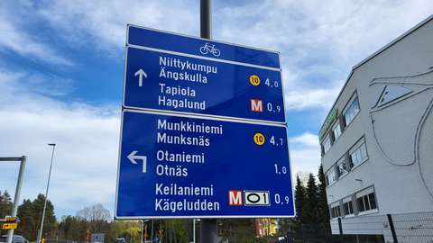
New signs have been installed throughout the City of Espoo’s cycling network to make cycling smoother and to provide clear and uniform signage around Espoo. Most of the installation work has been completed during 2026, but some signs will be installed after summer 2026 in connection with other ongoing roadwork projects.
Advance direction signs for cycling are new traffic signs introduced in 2020 following amendments to the Road Traffic Act. The signs guide cyclists to various destinations along direct, logical and safe routes. Various other aspects have also been taken into account when planning the routes. These include the steepness of the terrain, the standard of winter maintenance, and the number of intersections with traffic lights. Advance direction signs provide cyclists with information on alternative routes to their destinations during their journey. The destinations shown on the signs are typically city districts and their sub-areas. Other destinations on the signs include well-known places such as stations, marketplaces, squares and other notable landmarks.
Advance direction signs contain a range of useful information for cyclists, such as distances to destinations and symbols. In addition to the symbols specified in the Road Traffic Act, the signs also display the route numbers of regional main routes, shown on either a pink or yellow background. The pink regional main routes remain within Espoo, while the yellow routes extend outside the city. Regional main routes connect two major destinations. The EuroVelo 10 route is indicated by a symbol featuring a ring of stars and the number 10. EuroVelo 10 is a scenic tourist route that extends beyond Finland’s borders and goes around the Baltic Sea. The advance direction signs indicate the remaining distance to the destination in kilometres. The given distance is usually the distance to a square, a station or another significant area within the destination. The signs only have a guiding role; cyclists are not required to follow them.
The map available for download at the end of this press release shows the numbered routes indicated on the advance direction signs. The numbered routes consist of baana routes and other key cycling routes connecting major destinations.
The routes run between the following destinations:
1: Lauttasaari – Matinkylä – Kivenlahti
2: Munkkiniemi – Leppävaara – Bemböle – Nupuri (The route is not available on Säterinpuistontie between Leppävaarankatu and Turuntie and the Pellavaniementie and Pellavaniemenportti section due to construction work.)
4: Pitäjänmäki – Leppävaara – Espoon keskus – Kauklahti (The route is not yet in use in many areas. The route is under construction and will be opened in phases with the completion of the Espoo Rail Line by 2029.)
10: Lehtisaari – Tapiola – Espoonlahti
11: Keilaniemi – Otaniemi – Konala
20: Leppävaara – Niittykumpu – Matinkylä
21: Matinkylä – Suurpelto – Bemböle
22: Tapiola – Olari – Espoon keskus
23: Finnoo – Espoon keskus – Kalajärvi
24: Kivenlahti – Kauklahti
25: Leppävaara – Laaksolahti
Ring Road 1: Keilaniemi – Leppävaara – Konala
Ring Road 2: Haukilahti – Mankkaa
Ring Road 3: Bemböle – Hämeenkylä
EuroVelo 10: Kivenlahti – Lauttasaari
In addition to the advance direction signs for cycling, other signs are also being installed during the project. Within Espoo, place name signs for cycling are used where necessary to indicate arrival at a destination. At the city boundaries, they indicate arrival in Espoo.

Together, all of the signs form a comprehensive network that serves cyclists both within the city and in neighbouring municipalities. The new signs cover the entire City of Espoo, except for sparsely populated areas and some recreational areas. Most of the signs have been installed in densely built urban environments that have a large number of cyclists and route options. There may be temporary gaps in the signage system, as some of the routes are still under construction and their signs will be installed later.
The advance direction signs for cycling are part of a broader effort to make sustainable travel smoother, safer and easier for everyone. The City of Espoo encourages residents to familiarise themselves with the new signs and to provide feedback through the feedback system. With feedback, the service can be developed together with the users.
All signed and numbered cycling routes are available in the City of Espoo’s map service(external link, opens in a new window).
Downloadable files
Map of numbered routes(external link, opens in a new window)